
Introducing the island of Tobago, continued, pages 6 and 7
[page 6]
The Line of almost continuous Bays on the Southside of the
Island, affords shelter and anchorage for merchant vessels
which arrive with stores, and to load with produce from the
Plantations; - But, this is not the Coast, which renders suitable
accommodations to ships of war;- or has the bearings the most
favorable, for the directions of a general Commerce:- it is however
and specially laying to advantage for one important branch
of Trade, by the Channel of the Oronooko.
The Northern Coast of Tobago, is on every consideration of
uses, in War or Peace, of the Greatest Import: - a sketch of its
line of Country, as seen three leagues at sea, will give a general
idea, of its range of highlands, for twenty of Thirty two miles, its
entire length on the Geographic base:- The Inequalities of the
Ground, would make the distance to the Traveller much greater.
The Plain reaching from near Courland to the western
extremity of the island is so level, that from the one side, the
feathered heads of the mountains Cabbage trees may be descried
on the opposite coast:- at the western end, four miles across
and bearing direct, on Trinidad, only six leagues distant,
is a deep Bay, opening two miles on the chord[?] of entrance,
and shelterd from the prevalent winds by the entire length
of the Island: - It has good anchorage for ships of the line, - and
the station Commands Trinidad.

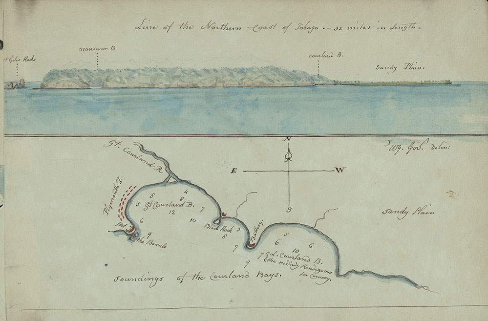 Line of the northern coast of Tobago, 32 miles in length and soundings of the Courland Bays, page 7Reproduced here are two separate illustrations drawn by Young and adjacent to each other on the same page.
One is a perspective watercolour sketch, viewing the island of Tobago from the north side. The other is a detailed map of the Courland Bays, with relevant information regarding their soundings.
The perspective watercolour sketch is an attempt to capture visually key information concerning the island. Coupled with the information in the title regarding the length of the island, it attempts to create a sense of perspective for the reader of the report.
Features of note include St Giles Rocks, Man o’ war Bay, the Courland Bays and Sandy Plains.
The second sketch examines in more detail the Courland Bays, and highlights in red potential sites for a battery and, as suggested in the Essay, a post office. The soundings detailed would have provided important information to anyone with naval experience aiding assessment of the suitability of the area for the establishment of a port.
In this exhibition
- Background information
- Gallery and transcription
- Introducing the Essay
- Dedication leaf and initial pages, 1 and 2
- Introducing the island of Tobago, pages 3, 4 and 5
- Introducing the island of Tobago, continued, pages 6 and 7
- Climate and geography, page 8
- Climate and geography, continued, page 9
- Casualty reports from 1808 and 1809, page 10
- Natural resources of the island
- Tobago's relative position
- The Commercial & political importance of the island of Tobago
- The Commercial & political importance of the island, continued
- Port of enterprize and command, page 29
- Orinoco River, page 30
- Appeal to British merchants, page 31
- Historical political instability of the island, page 32
- The reach of the Orinoco River, page 33
- Potential trade agreements with Spain, page 34
- Further trade routes with South America, page 35
- Establishing the port of Courland, page 36
- Prospects of national advantage, page 37
- Conclusions
- Military significance of Man o' war Bay, page 38
- Further significances, page 39
- Military consensus, page 40
- French intentions for the island, page 41
- Suitability as a port for ships of war, page 42
- Relative safety of the island, page 43
- The necessity to prepare for conflict, page 44
- Revelations of an inside source, page 45
- Fas est, et ab hoste doceri, page 46
- Select bibliography